


Directions, Maps & Weather
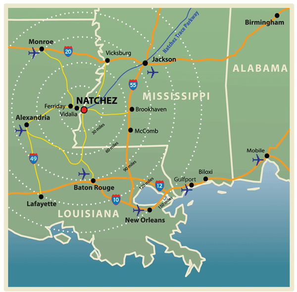
Looking for directions to Natchez, Mississippi? Natchez is located in the southwest corner of Mississippi on the mighty Mississippi River, across from Vidalia, Louisiana.
Getting to Natchez
Airports
Natchez-Adams County Airport (HEZ)
434 Airport Road
(601) 442-3142
The Natchez-Adams County Airport is an excellent facility with a 6,500-foot runway able to host landings of Boeing 737s and DC9s, as well as smaller craft.
Beginning July 1, 2026, United Express (powered by SkyWest Airlines) will have daily commercial jet service to and from Houston’s George Bush Intercontinental Airport. Travel to Natchez from anywhere in the world!
Alexandria International Airport (AEX)
(318) 449-3504
70 miles from Natchez
Baton Rouge Metropolitan Airport (BTR)
(225) 355-0333
81 miles from Natchez
Jackson International Airport (JAN)
(601) 939-5631
105 miles from Natchez
New Orleans International Airport (MSY)
(504) 464-0831
170 miles from Natchez
Railway
Amtrak
(800) 872-7245
Brookhaven- 64 miles from Natchez
McComb- 69 miles from Natchez
Ground Transportation
Enterprise Rent-A-Car
321 D’Evereux Drive
(601) 442-4600
Natchez Bus Terminal & Charter Services
127 Wood Avenue
(800) 981-7743
(601) 445-5291
Fares & Schedules
(800) 231-2222
Natchez Transit Authority
127 Wood Avenue
(601) 445-7568
6am-6pm pick up and drop off anywhere within the city limits for visitors. Call to schedule.
Once you arrive in Natchez, be sure to stop by the Visit Natchez to pick up your tear-off map with locations of all of the downtown shops, restaurants and attractions.
Weather
Mild Highs & Gentle Lows All Year Long
In a way, much of the beauty of Natchez is thanks to the weather, and we don’t just mean lush grass, live oaks, and Spanish moss! It was the gentle subtropical climate — mild temperatures, moderate rainfall and plenty of sunshine — that made Natchez the heart of the cotton belt, and that perfect weather for crops is what attracted planters whose beautiful mansions still stand today.
If you love the outdoors, spring is a great time to visit, with Natchez weather featuring highs in the 70s and 80s and lows in the 50s and 60s at night. The lazy days of summer hover in the high 90s, while summer evenings in the mid 70s invite you to stay up, stay out and enjoy the nightlife.
Fall begins warm in Natchez, cooling to the high 70s by day in November and a mild 45-50 degrees overnight. Even if you’re visiting in winter, you can still pack light! In the heart of January—our coolest month—daytime highs hit the 50s on average and lows stay right around 40 degrees.
Natchez Weather: Monthly Averages
| MONTH January February March April May June July August September October November December | HIGHS (°F) 58 63 70 77 83 89 91 91 87 79 68 61 | LOWS (°F) 39 42 49 55 63 69 72 71 66 55 47 41 | RAINFALL (IN.) 6.4 5.0 6.7 6.1 5.5 4.7 4.0 3.9 3.7 4.0 5.6 6.4 |